Addis Ababa, 10 October 2023, (ECA) - Africa should harness geospatial technology to generate effective statistical data that supports decision making to accelerate sustainable development on the continent, says Oliver Chinganya, Director of the Africa Center for Statistics (ACS) of the Economic Commission for Africa.
Mr. Chinganya, speaking during a webinar seminar of the Stats Talk Africa series, on Demystifying Geospatial Information for Official Statistics in Africa, highlighted that geospatial Technology has become an invaluable tool for collecting and organizing geographic data.
Geospatial technology combines the power of Geographical Information Systems(GIS) and remote sensing tools to generate data specific to a location or geography.
For a long time African Statistical Systems have been struggling to make use of location based data in their collection, analysis, and dissemination of data but recent advances in geospatial technology and data science have now enabled Africa to address discrepancies in statistical data, Mr. Chinganya said.
Geospatial technology has enabled a much more efficient method of data collection from a range of sources, such as satellite imagery, mobile phones, and drones which can be instantly analyzed to provide meaningful insights, said Mr. Chinganya, adding that this data can be shared online in real-time revolutionizing the way African countries are obtaining information for decision-making.
The Stat Talk webinar series promotes dialogue on data and statistics and innovative tools with data experts and users to promote better understanding of statistical concepts and better utilization of information.
“The role of geospatial technology in the African statistical systems is that geospatial technology offers high resolution precision and time efficiency,” said Mr. Chinganya, who noted that traditional statistical methods in Africa often lack depth and detail due to aggregation.
Underscoring that advanced geospatial technology is key for promoting data democratization in africa, Mr. Chinganya said geospatial technology allows for large scale initiatives such as the population and housing census. For instance, Burundi benefitted from the deployment of this technology in the implementation of its 2024 housing and agriculture census.
In this particular case the application of geospatial information in the Burundi census showed the potential for geospatial information in the development of a dwelling framework and database for 2.5 million dwellings. Furthermore the use of the technology reduced the time frame for collecting the data from about 18 months to 5 months as well as the costs from millions of dollars to $40 000.
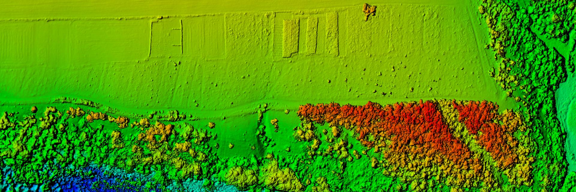
In a presentation on geospatial technology, ECA Statistician, Ayenika Godheart Mbiydzenyuy, noted that geospatial technology has many applications that enable the accurate mapping, measurement and location of information that can be interpreted to make sense of trends. This geospatial technology has been used to map transport networks like roads, water points, planned activities, demographic studies to geological surveys for minerals using remote sensing techniques.
He said geospatial technology leverages innovative tools like satellite imagery, mobile phones and drones. Satellite scans now capture atmospheric data, usage patterns from mobile devices, paint a picture of living patterns while drones provide detailed images of remote locations. This data can be used to generate geostatic maps that provide a more complete and intricate understanding of an area .
Mr. Chinganya highlighted that geospatial technology is revolutionary in breaking down traditional systems and linking each statistical data point to a precise location on Earth.
“As we move further into the 21st century, the development of Africa is no longer only determined through conventional number crunching, but also through the analysis of diverse geographic scales,” Mr. Chinganya noted, admitting that Africa was still challenged by lack of infrastructure and skilled personnel to adequately harness geospatial technology.
“With the advances of geospatial technology, the potential of the future can be unlocked, allowing us to transform abstract ideas into tangible action. Not only does this allow us to identify problems, but also to devise solutions,” said Mr. Chinganya.
Issued by:
Communications Section
Economic Commission for Africa
PO Box 3001
Addis Ababa
Ethiopia
Tel: +251 11 551 5826
E-mail: eca-info@un.org